How to Find GPS Coordinates (Latitude and Longitude) on a Map
How to Find GPS Coordinates (Latitude and Longitude) on a Map
Ever needed to share the exact location of a picnic spot in a huge park, a specific fishing spot on a lake, or a meeting point that doesn't have a street address? In these moments, a normal address won't do. What you need are GPS coordinates. This article will simply explain what GPS coordinates are and introduce a free, easy-to-use tool to help you find them for any place on Earth.
What Are GPS Coordinates, Anyway?
Think of GPS coordinates as a universal address for every single point on our planet. This "address" is made up of two numbers: latitude and longitude. Together, they can guide you to a precise location with incredible accuracy.
What is Latitude?
Latitude tells you how far north or south a location is from the Equator. The Equator is the imaginary line that runs around the middle of the Earth, splitting it into the Northern and Southern Hemispheres. The Equator itself is at 0∘ latitude. Locations north of the Equator have positive latitude values, up to 90∘ N (the North Pole). Locations south of the Equator have negative latitude values, down to −90∘ S (the South Pole). You can think of lines of latitude as horizontal rungs on a ladder, with the Equator being the middle rung.
What is Longitude?
Longitude tells you how far east or west a location is from an imaginary line called the Prime Meridian. This line runs from the North Pole to the South Pole, passing through Greenwich, London. The Prime Meridian is at 0∘ longitude. Locations to the east have positive longitude values, up to 180∘ E. Locations to the west have negative longitude values, down to −180∘ W. You can picture lines of longitude as the vertical slices of an orange, all meeting at the top and bottom.
A Quick Look at the Numbers: Why 90° and 180°?
You might wonder why latitude stops at 90 and longitude goes to 180. It's not random—it's based on the simple geometry of a sphere.
Latitude is about the angle up or down. Imagine you're at the very center of the Earth. If you point straight at the Equator, that's your 0∘ starting line. As you move your finger north, the angle increases. By the time you are pointing directly at the North Pole, you've made a right angle—which is exactly 90∘. You can't go any further north than that! The same logic applies to the South Pole at −90∘.
Longitude is about the angle around. Longitude measures the full 360∘ circle around the Equator. We use the Prime Meridian as the 0∘ starting point. From there, you can travel 180∘ (half a circle) to the east, or 180∘ (half a circle) to the west. Both paths meet at the exact same line on the opposite side of the Earth. That's why the maximum is 180—it's the halfway point around the world. So, in short: latitude is a quarter-circle journey from the Equator to a pole (90∘), and longitude is a half-circle journey from the Prime Meridian to the other side of the world (180∘).
The 3D model we built below shows the basic grid system we use to pinpoint any location on Earth: latitude and longitude.
The bright red circle is the Equator, which sits at 0° latitude. It divides the world into the Northern and Southern Hemispheres. Any location north of the Equator has a positive latitude value, going all the way up to +90° at the North Pole. Any location south of the Equator has a negative latitude, extending down to -90° at the South Pole.
The green vertical line is the Prime Meridian, our starting point for longitude at 0°. Locations to the east of this line have positive longitudes, stretching to +180°. Locations to the west have negative longitudes, reaching -180°. The yellow line on the opposite side of the Earth represents this 180° longitude line, where the eastern and western measurements meet.
An Easy Way to Find and Visualize Coordinates
Now that you know what coordinates are, how do you find them? While there are many complex tools out there, we wanted to create something straightforward and visual. That’s why we built the GeoFan Coordinates Finder. It’s a free web tool designed to make finding, sharing, and understanding GPS coordinates simple for everyone. Here’s what you can do with it:
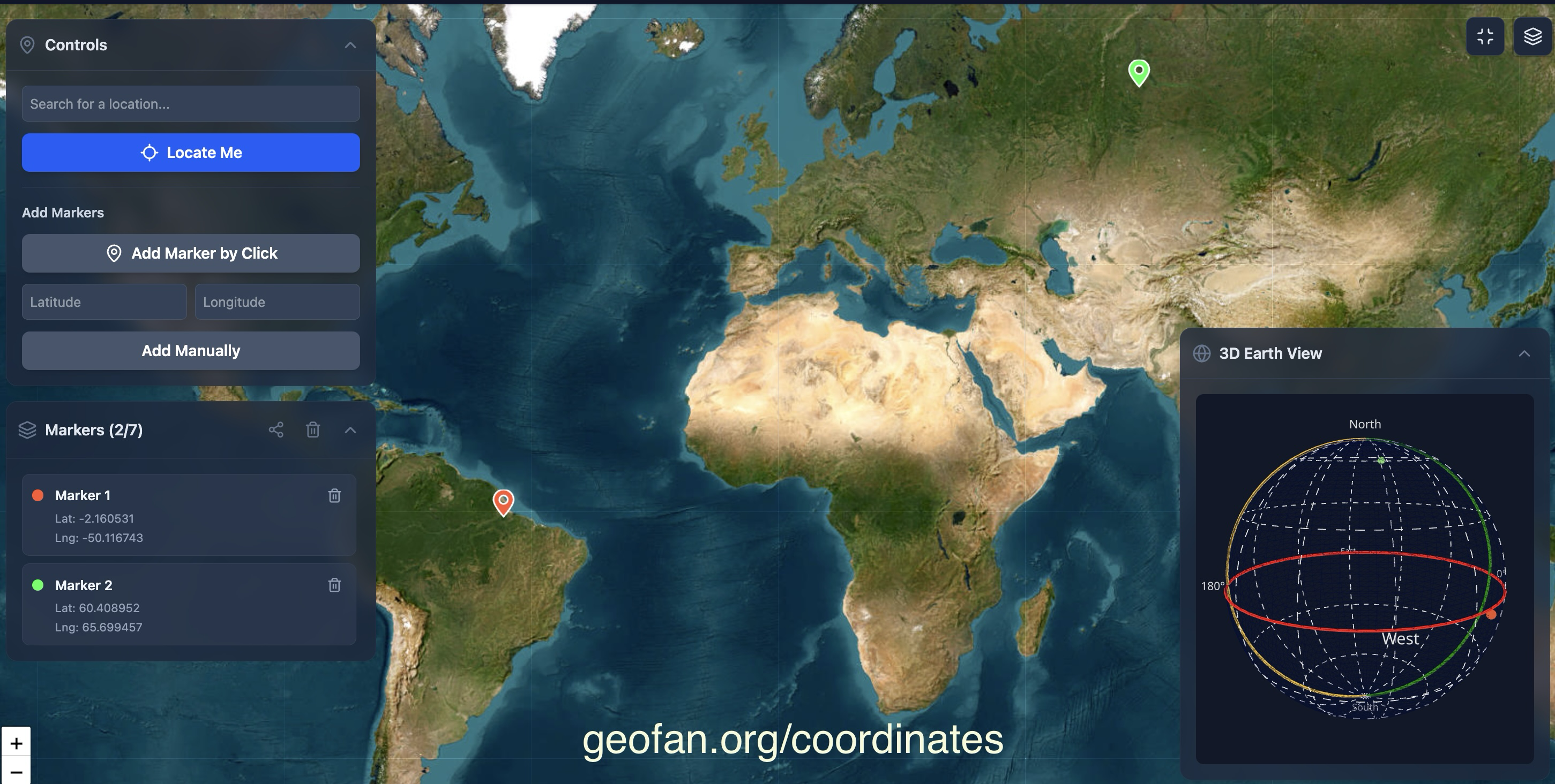
1. Place Markers to Find Coordinates
The most intuitive way to find coordinates is to simply point to a location. Navigate the map by dragging and zooming. Click anywhere on the map to drop a pin. Instantly, the exact latitude and longitude for that spot will appear in the sidebar. You can add multiple markers, and each one will have a different color to keep things organized.
2. Find a Location from Known Coordinates
What if you already have a set of coordinates? No problem. In the sidebar, you'll find input boxes for Latitude and Longitude. Simply type or paste the values in and click "Add Marker." The map will automatically place a pin at that precise location, showing you exactly where it is in the world.
3. See Your Points on a 3D Earth 🌍
This is where things get really cool, especially for learners. Understanding coordinates on a flat map is one thing, but seeing them on a globe gives you a true sense of global position. Our tool includes a 3D Earth display right below the map. Every marker you place on the 2D
map will also appear on the 3D globe, keeping its assigned color. This feature is perfect for students, teachers, or anyone who is curious to visually understand how latitude and longitude wrap around our planet.
Get Started!
Whether you're a traveler needing to mark a specific location, a student learning about geography, or just curious about the world, having a good coordinate finder is essential. Give our tool a try—it's free and simple. Head over to GeoFan Coordinates Finder and start exploring. Happy mapping!